
All Systems Go
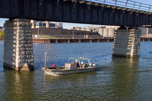
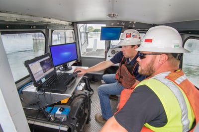 At Brennan, we utilize hydrographic survey systems to measure progress on all of our dredging projects. These systems typically include a positioning system, such as RTK-GPS, and a multi-beam echo-sounder. The Real Time Kinematic, Global Positioning System, or RTK-GPS, is a precise satellite navigation tool, whereas an echo-sounder is a sonar device for measuring depth. Combining the two allows us to achieve very accurate measurements on the location of the river bottom. We take the data points created during these measurements and create a 3-dimensional model using Hypack® software. By running a survey before we dredge, and then one afterward, we can create two models and compare them to one another. The difference between the two models is the total volume of in-situ yardage that we have removed. Typically, we are paid by the in-situ volume of sediment (in cubic yards) that we remove so it is very important that these measurements are extremely accurate. Therefore, establishing quality control checks on the equipment before we survey is an extremely important step in achieving accurate measurements.
Systems Check
The RTK-GPS units rely on a minimum of three satellites. As a quality control check, we will use established ground control points to measure and compare latitude and longitude positions. The measurements must fall within a minimum tolerance, and if the points are inaccurate, our survey will be inaccurate. We must then adjust our base station, or change our software settings and start the process over. Geodetic control points, key points placed in the ground by third-party professional surveyors, serve as our benchmark to ensure RTK-GPS accuracy.
Sounding it Out
 The multi-beam echo-sounder transmits a sound pulse through the water column. It then measures the time it takes for the pulse to reflect off the bottom and return. The longer the return time, the deeper the water. Before every survey, we have to calibrate our echo-sounder for accuracy. To measure sound speed, we deploy a special sensor called a CTD, a type of sound speed profiler that measures conductivity temperature, and depth. This sensor measures the speed of sound at known depths.
Fitting all the Pieces Together
Many times a single tool will not accomplish everything, so we must combine many tools to work together as a system. In addition to the RTK-GPS units and the multibeam echo-sounder, we use pitch and roll sensors, scanning total stations, ultra-short baseline acoustic positioning systems, and side-scan sonars. Each piece has a specific function, and when combined they can create a very effective system that can collect accurate data.
TQM or Bust
Our quality control process is very important to us. Any inaccuracies in the measurements can cost us greatly. It can lead to over-dredging, under-dredging, and the need for second passes. All of these issues will impact our completion deadlines, and could directly cost us money. For instance, on an environmental project, we have to cover the cost of the over-dredged yards. This can be an extremely expensive penalty when considering the disposal costs of the sediment!