- Environmental
- Marine Construction
- Dam Construction
- Harbor Management
- Railroad
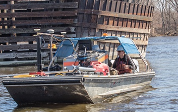
Brennan’s hydrographic surveys leave little to the imagination. We use state-of-the-art positioning and depth measurement equipment operated by surveyors who specialize in hydrography. Our customized survey vessels are specially designed to access shallow areas and can collect bathymetric data right up to the dam.
Headed by a licensed hydrographer, the Brennan survey department often teams with owners and engineers alike to gather critical data to model and analyze conditions around dams, levees and embankments. Using RTK-GPS for precise positioning, multi-beam echo-sounders for depth measurement, and ancillary sensors to account for the various movements of the vessel, our surveyors can collect very accurate data sets that can be used to develop detailed models of the river bottom. These models can be used to calculate volumetric quantities of scours holes, voids, and sediment build-up to a high degree of accuracy. Deliverables will include full color digital images, georeferenced data sets, and 3-dimensional models that give the viewer a lifelike view of bottom conditions.

818 Bainbridge Street
La Crosse, WI 54603
Phone: 608/784-7173
Fax: 608/785-2090
Payroll Fax: 608/881-6519
24/7 Service
Call 800-658-9027
Copyright © 2015 J.F. Brennan Co. Inc.